HABITAT AND RECREATIONAL ACCESS PROJECT FORMS
Project Title: Bad Rock Canyon Conservation and Public Access Project
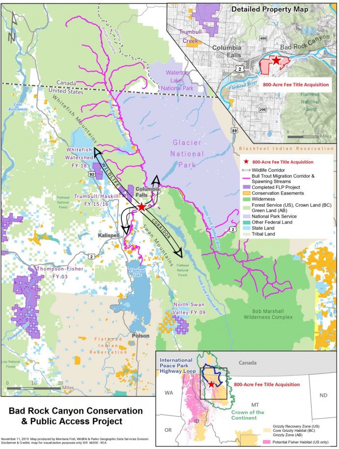
Project Description: The Bad Rock Canyon Conservation and Public Access Project is a rare opportunity to provide recreational access for the public on 800 acres of private property adjacent to a community and protect vital wildlife habitat and a travel corridor connected to Glacier National Park and the Bob Marshall Wilderness. The project will also protect the healthy function and excellent water quality of the Flathead River, the heart of the Crown of the Continent Ecosystem, which flows into Flathead Lake, the largest freshwater lake in the western U.S. and one of the cleanest lakes in the world. The project property is primarily riparian forest habitat along 1.6 miles of the Flathead River just east of Columbia Falls. It includes a mile of a warm spring creek, 80 acres of wetland, and 120 acres of cottonwood gallery forest. The project is located just downstream of Glacier National Park and the Bob Marshall Wilderness Complex at a focal point of landscape connectivity at the mouth of Bad Rock Canyon, a geographic pinch point where the Flathead River flows through private land in a narrow canyon between two mountain ranges that are public land. It adds to a 12,000-acre network of conserved riparian lands along 43 miles of the Flathead River that flows through private property; this network conserves 53% of the wetlands, 50% of the high- quality riparian areas, 45% of the shallow groundwater, and 42% of the 100-year floodplain in this focus area. The project will provide recreational opportunities for the public including hiking, biking, hunting, and fishing on the 800 acres of land adjacent to the Flathead River two minutes from downtown Columbia Falls. The project involves purchasing the fee title of the 800 acres of private property and the land being owned and managed by Montana Fish, Wildlife and Parks.
The project protects habitat used by a plethora of wildlife including two threatened species, grizzly bear and bull trout. The project lands are part of a buffer area that was identified in the U.S. Fish and Wildlife Service 2018 Conservation Strategy for the Grizzly Bear in the Northern Continental Divide Ecosystem as vital habitat for female bears and necessary to sustain a recovered population within the federally-designated recovery area. Montana Fish, Wildlife and Parks (MFWP) radio collar data show six different grizzly bears using the project property for foraging and as a migration corridor between the Swan and Whitefish mountain ranges. MFWP data also show bull trout using the side channel habitat of the Flathead River adjacent to the project property year-round and the 1.6 miles of the river bordering the project property when migrating from Flathead Lake to spawning areas up to 150 miles away in Canada. In addition, 43 Species of Greatest Conservation Need as identified by the State Wildlife Action Plan use the project property
including fisher, wolverine, westslope cutthroat trout, peregrine falcon, Lewis’ woodpecker, and western toad. Fifty percent of the property is designated as potential fisher habitat, an extremely rare species of concern. The property provides low elevation, moist, productive refugia adjacent to a stronghold of public lands including Forest Service, Glacier National Park, and the Bob Marshall Wilderness Complex in the Crown of the Continent Ecosystem. This low elevation, moist productive habitat is needed by wildlife struggling to adapt to a warmer, dryer climate. The project property also serves as winter range for a herd of elk and white tailed deer.
The project protects vital bird habitat and intermountain valley floor wetland habitat identified as important in the Intermountain West Joint Venture Implementation plan and three national bird conservation plans (the North American Waterfowl Management Plan, the North American Waterbird Conservation Plan, and the Partners in Flight Land Bird Conservation Plan). The mile of warm spring creek protected by the project provides important bird habitat in winter and spring when other areas are ice-covered especially since the Flathead Valley is a key stopover in the Intermountain West portion of the Pacific Flyway used by hundreds of thousands of waterfowl annually. The wetlands on the project property are also key habitat for the migrating waterfowl. Its cottonwood forest is critical as cottonwood forests are in decline yet provide habitat for more than half the bird species in Montana with hundreds of thousands of migrating birds using them for food and shelter. In the western U.S., they support a higher diversity of breeding birds than all other western habitats combined.
The project will provide recreational opportunities for the public on 800 acres of land adjacent to the Flathead River two minutes from downtown Columbia Falls. This public access will include a non-motorized, primitive trail for hikers and bikers that will connect to Columbia Falls and Glacier National Park. It will also continue popular and unique youth and disabled hunting opportunities for deer and elk managed through a free lottery system by MFWP each fall. In addition, it will provide 1.6 miles of shoreline access along the Flathead River for fishermen.
However, the project property is highly developable and threatened by subdivision and development as it is adjacent to the rapidly growing city of Columbia Falls and development around the project area is booming and land values are soaring. The project land is in private ownership by Columbia Falls Aluminum Company (CFAC), a subsidiary of Glencore, a multi-national company, looking to dispose of the property. However, CFAC has entered into an agreement with Flathead Land Trust giving us two years to obtain the funding to purchase the property to have a conservation outcome. If the project fails, the property will be sold, subdivided, and developed into highly sought after riverfront lots.
Project Location (Legal Description if available): Private land located in Flathead County in northwest Montana just east of Columbia Falls and south of the Flathead River in T30N R20W Sect. 3, portion of TR6 in L2-3 & PT ABD RD south of the Flathead River; T30N R20W Sect. 9, TR3 in L5, SE4NE4, TR4 in SE4, TR7 in L6-9; T30N R20W Sect. 10, TR1, TR4, TR4A in N2, TR2 in E2E2; T30N R20W Sect. 11, TR1 in W2W2, TR2BA in SE4NW4; and T30N R20W Sect. 16, TR10 in N2NE4. It is not part of the land that was used for aluminium production and there is no evidence of hazardous materials or contamination of the site. The project property is adjacent to Hwy. 2, and just across the Flathead River from the city of Columbia Falls. It is adjacent to private land on three sides and state land to the east which connects to millions of acres of public land including the Flathead National Forest, Glacier Park, and Bob Marshall Wilderness Complex. It is at a focal point of landscape connectivity at the mouth of Bad Rock Canyon, a geographic pinch point where the Flathead River flows through private land in a narrow canyon between the Swan and Whitefish mountain ranges which are public land.
Submitted By: Flathead Land Trust, Inc. (non-profit organization)(P.O. Box 1913, Kalispell, MT 59903; 406-752-8293); Contact: Laura Katzman (lkatzman@flatheadlandtrust.org)
Coordinated With: Landowner, Steve Wright of CFAC, a subsidiary of Glencore, (406) 892-8211 and John Stroiazzo of Glencore, (203) 918-5892; Alan Wood (406) 751-4595 and Kris Tempel
(406) 751-4573 of MFWP (agency working with to hold title to property acquired); and Jamie Belt of Gateway to Glacier Trail (406) 892-4613 (group that has license to build public trail on project property)
Project Type:* Recreational Access: The project will provide recreational opportunities for the public on 800 acres of private land along the Flathead River near the city of Columbia Falls that could have been sold, subdivided, and developed into highly sought after riverfront lots. The recreational access will include a non-motorized, primitive trail for hikers and bikers; continue popular and rare youth and disabled hunting opportunities for deer and elk; and provide 1.6 miles of shoreline access on the Flathead River for fishermen; Habitat Improvements: The project protects critical wildlife habitat at a focal point of landscape connectivity at the mouth of Bad Rock Canyon, a geographic pinch point connecting two mountain ranges and a riparian travel corridor for wildlife such as grizzly bears traveling from Glacier Park and the Bob Marshall Wilderness. It also protects 800 acres of riparian forest habitat critical to fish and wildlife including grizzly bear and bull trout with valuable cottonwood forests, wetlands, and a warm spring creek that functions as low elevation, moist, productive refugia during climate change and serves as winter range for a herd
of elk and white tailed deer; and Fisheries Enhancements: The project protects 800 acres of riparian forest along 1.6 miles of the Flathead River used as a migratory corridor for bull trout migrating from Flathead Lake to spawning areas up to 150 miles away in Canada and as a wintering area and year-round habitat for bull trout and westslope cutthroat trout. It also protects a mile of a spring creek, 80 acres of wetlands, 100-year floodplain, and shallow groundwater important for the healthy function and excellent water quality of the Flathead River and Flathead Lake.
Management of Properties: MFWP will own and manage the property. MFWP will manage the riparian forest for fish and wildlife and protect a key travel corridor for fish and wildlife. They will also develop a non-motorized, primitive trail for hikers and bikers on the property in coordination with the Gateway to Glacier Trail group. MFWP would continue unique youth and disabled hunting opportunities for deer and elk with a free lottery system. They would also provide 1.6 miles of shoreline access on the Flathead River for fishermen.
Size of Project Area: The project would protect approximately 800 acres of forested riparian habitat critical to fish and wildlife along 1.6 miles of the Flathead River east of Columbia Falls at the mouth of Bad Rock Canyon. The project would also protect a mile of a warm spring creek, 80 acres of wetland, and 120 acres of cottonwood gallery forest. The project property connects to a stronghold of millions of acres of public lands including Forest Service, Glacier National Park, and the Bob Marshall Wilderness Complex and adds to a 12,000-acre network of conserved riparian lands protecting the healthy function and excellent water quality in 43 miles of the Flathead River that flows through private land into Flathead Lake, the largest freshwater lake in the western U.S. The project would create public access on 800 acres including access for hiking, biking, hunting, and fishing.
Implementation Schedule: Projected closing of December 2021
Total Project Cost: $7,090,000.
MFWCT Funds: Flathead Land Trust is requesting $125,000 in 2020 and $125,000 in 2021 in MFWCT funds.
12-13. Matching/Cooperator Funds: We have applied or plan to apply to the Forest Legacy, Recovery Land Acquisition, and Habitat Montana programs and other grants/partners including the National Fish & Wildlife Foundation Acres for America Program, The Nature Conservancy’s Natural Climate Solutions Accelerator Program, Vital Ground Foundation, and Rocky Mountain Elk Foundation to provide the balance or $6,840,000 funds needed for the project.
Matching/Cooperator Funding | Contribution |
Forest Legacy Program | $4,000,000 |
Recovery Land Acquisition | $1,000,000 |
Habitat Montana | $1,500,000 |
Other Grants/Partner Contributions | $ 340,000 |
Total | $6,840,000 |
Project Objective (s) will be accomplished with the strategy of purchasing fee title of the 800-acre CFAC property and the land being owned by MFWP in the future.
Provide public access on 800 acres of land adjacent to the Flathead River and the city of Columbia Falls including a non-motorized, primitive trail for hikers and bikers; continuing popular and unique youth and disabled hunting opportunities for deer and elk; and providing
1.6 miles of shoreline access along the Flathead River for fishermen.
Protect vital riparian forest habitat used by a plethora of wildlife including threatened grizzly bears and 43 Species of Greatest Conservation Need as identified by the State Wildlife Action Plan with valuable cottonwood forests, wetlands, and a warm spring creek that functions as low elevation, moist, productive refugia during climate change and serves as winter range for a herd of elk and white tailed deer.
Protect a focal point of landscape connectivity at the mouth of Bad Rock Canyon at a geographic pinch point connecting two mountain ranges and a riparian travel corridor for wildlife such as threatened grizzly bears and Species of Greatest Conservation Need including fisher and wolverine as well as a large diversity of other wildlife including wolf, mountain lion, and black bear traveling from Glacier Park and the Bob Marshall Wilderness.
Protect the healthy function and excellent water quality of the Flathead River, the heart of the Crown of the Continent Ecosystem, which flows from Glacier National Park and the Bob Marshall Wilderness into Flathead Lake, the largest freshwater lake in the western U.S.
Protect aquatic habitat for threatened bull trout using the Flathead River along the project property as a migratory corridor from Flathead Lake as far as 150 miles upstream into Canada to spawn as well as habitat used by westslope cutthroat trout and other aquatic species.
Area Description:
The project property is private land located in northwest Montana just east of Columbia Falls and south of the Flathead River. It is adjacent to Hwy. 2, the main access to Glacier National Park which in 2018 experienced 2.8 million vehicle trips so the project land along the highway would be highly developable into commercial real estate. It is also just across the Flathead River from the city
of Columbia Falls and has highly developable terrain with waterfront, stunning views, and a remote feel only minutes from towns, shopping, and commercial transportation. However, it is also at the mouth of Bad Rock Canyon, a focal point of landscape connectivity at a geographic pinch point where the Flathead River flows through a narrow canyon between the Swan and Whitefish mountain ranges and connects to millions of acres of public land including the Flathead National Forest, Glacier Park, and Bob Marshall Wilderness Complex. It is critical to fish and wildlife and could be a recreational asset for the public of the nearby community of Columbia Falls (see attached maps).
The project land is in private ownership by CFAC, a subsidiary of Glencore, a multi-national company, looking to dispose of the property. If the project fails, the property will be sold, subdivided, and developed into highly sought after riverfront lots.
Project Analysis: *
The proposed project will protect 800 acres of vital wildlife habitat from being sold, subdivided, and developed. The project will protect riparian forest including valuable cottonwood forests, wetlands, and a warm spring creek that functions as low elevation, moist, productive refugia during climate change for grizzly bear and other wildlife and winter range for a herd of elk and white tailed deer. The project will also protect a focal point of landscape connectivity at the mouth of Bad Rock Canyon at a geographic pinch point connecting the Swan and Whitefish mountain ranges and a riparian travel corridor for wildlife traveling from Glacier Park and the Bob Marshall Wilderness. The project will protect the healthy function and excellent water quality of the Flathead River which flows from Glacier National Park and the Bob Marshall Wilderness into Flathead Lake, the largest freshwater lake in the western U.S. It will also protect aquatic habitat for bull trout using the Flathead River along the project property as a migratory corridor from Flathead Lake as far as 150 miles upstream into Canada to spawn as well as habitat used by westslope cutthroat trout and other aquatic species.
The proposed project will provide public recreational opportunities on 800 acres of private land just east of the city of Columbia Falls that would otherwise be sold, subdivided, and developed. The project will include a non-motorized, primitive trail for hikers and bikers; continue popular and unique youth and disabled hunting opportunities for deer and elk; and provide 1.6 miles of shoreline access along the Flathead River for fishermen. The public access on the project land will be communicated to the public with signage, through MFWP, the City of Columbia Falls, and partner websites, through newspaper articles, and social media.
Existing Project Area Land Management: The property has had some timber harvest and historically some grazing on parts of it. Youth and disabled hunters have been able to use the property to hunt elk and deer through a free lottery system managed by MFWP each fall. The Gateway to Glacier Trail group has a license to develop a public trail on the property. The proposed project would continue the popular and rare access opportunity for youth and disabled hunters and allow trail development to provide desired public access while protecting the vital wildlife habitat and security on the property. The proposed project will also allow the state to manage the riparian forest for wildlife and demonstrate to local forest landowners sustainable forest management which offsets stewardship costs while providing habitat and connectivity for fish and wildlife.
Use of MFWCT Funds: The MFWCT funds would be used to purchase the fee title of the 800- acre project property and would help us obtain the $1,667,000 of non-Federal match required for the Federal grants.
Project Monitoring: MFWP will own and manage the property including its forest, trail, wildlife and public use. The Gateway to Glacier Trail group would help develop and maintain the public trail.
Additional Comments: The project property is highly threatened by subdivision and development as it is adjacent to Columbia Falls and development around the project area is booming and land values are soaring. From 1990 to 2016, Flathead County experienced a 65% increase in population size while the city of Columbia Falls grew by 82%. Since 2011, the median home price in Columbia Falls has jumped from $100,000 to $309,500, a 300% increase. The property is highly developable as it has gently rolling terrain, waterfront, stunning views, and a remote feel only minutes away from towns, shopping, and commercial transportation. The property is two minutes from downtown Columbia Falls, 10 minutes from Glacier Park International Airport, 25 minutes from Kalispell, and 20 minutes from Glacier National Park. The property includes U.S. Hwy. 2 frontage which in 2018 experienced 2.8 million vehicle trips and would be highly developable into commercial real estate on the highway that is the main access to Glacier National Park.
CFAC has entered into an agreement which gives Flathead Land Trust two years to obtain the funding to purchase the property in order to have a conservation outcome. We hope the Montana Fish and Wildlife Conservation Trust can help us complete this valuable project and achieve meaningful conservation of this area with rich ecological significance and provide exceptional recreation opportunities for the public.
mouth of Bad Rock Canyon.
River downstream of Glacier National Park and near Forest Service land and Columbia Falls.

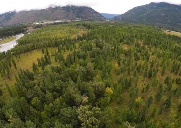
Project land at the mouth of Bad Rock Canyon along the Flathead River.
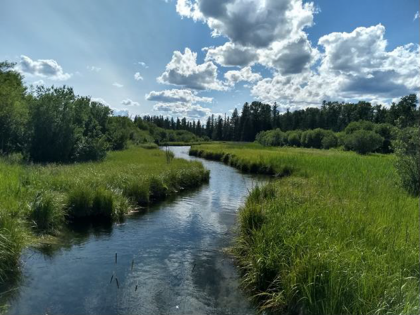
Looking downstream at warm spring creek and wetlands on project property.
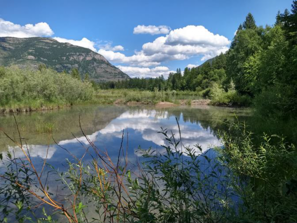
Looking upstream at warm spring creek and wetlands on project property with Bad Rock Canyon in background.

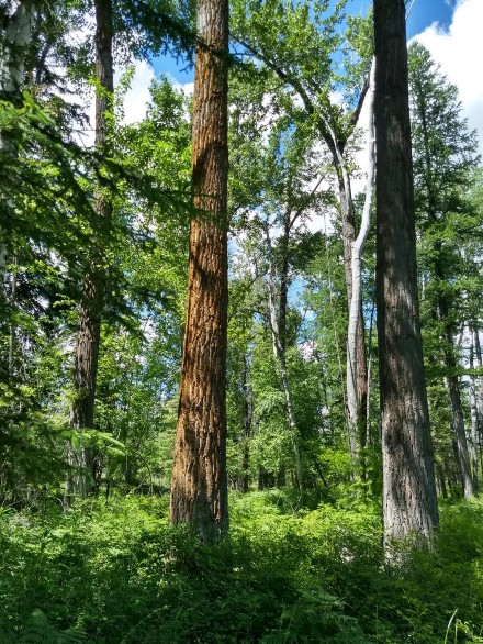
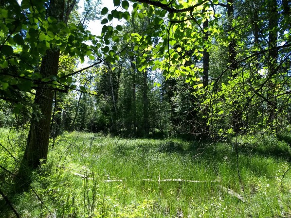
One of many wetlands dispersed throughout forest on project property.
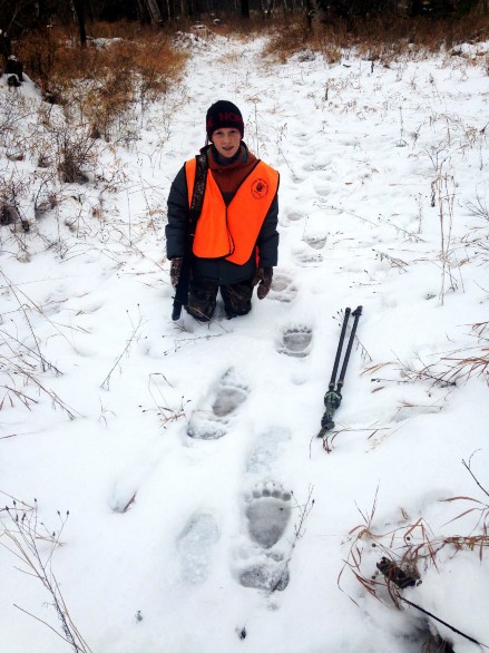
Large cottonwoods and variety of thick vegetation on project property (left); youth hunter with grizzly bear tracks on project property (right).